Neo 2 for Power Line Surveys in Complex Terrain: A Field
Neo 2 for Power Line Surveys in Complex Terrain: A Field-Focused Technical Review
META: A technical review of Neo 2 for surveying power lines in complex terrain, covering obstacle avoidance, ActiveTrack, D-Log workflow, battery management, and practical field tactics.
Power line surveying sounds straightforward until the terrain starts arguing back.
On a flat access road with a clear sky, almost any modern UAV can produce useful inspection imagery. Move that same task into broken hillsides, tree-lined corridors, ridgelines with crosswind, and valleys that distort both signal behavior and pilot sightlines, and the conversation changes fast. Aircraft handling matters more. Obstacle sensing stops being a brochure feature. Battery discipline becomes operational, not administrative.
That is the lens I used for this review of the Neo 2.
I come at this with a photographer’s bias. I care about image quality, yes, but I also care about whether the aircraft helps me get repeatable, readable data without adding friction to the mission. For power line survey work, the goal is not pretty footage for its own sake. The goal is to capture stable visual information around conductors, poles, towers, insulators, and right-of-way conditions while working safely in terrain that can punish lazy planning.
The Neo 2 stands out less because of one headline feature and more because of how several functions work together: obstacle avoidance, subject tracking, QuickShots, Hyperlapse, D-Log, and ActiveTrack. Some of those sound like creative tools. In practice, several can be adapted into useful capture methods for civilian infrastructure documentation when the pilot understands their limits.
Why complex terrain exposes weak drone setups
Power lines are linear assets. That means the aircraft often needs to move along a corridor rather than hover around a single point. In mountains, forests, and uneven ground, the inspection route tends to include three recurring complications.
First, relative altitude changes constantly. A drone that looks comfortably above terrain from your takeoff point can become much closer to rising ground a few hundred meters later.
Second, obstructions are irregular. Trees, guy wires, poles, branches, and slope-side vegetation create a cluttered environment where route planning cannot rely on a simple straight line.
Third, lighting is inconsistent. One span may be in harsh sun, the next in shadow, with bright sky behind conductors. That is exactly the kind of scene where image profile choices affect whether details survive post-processing.
This is where the Neo 2’s feature mix becomes operationally relevant rather than cosmetic.
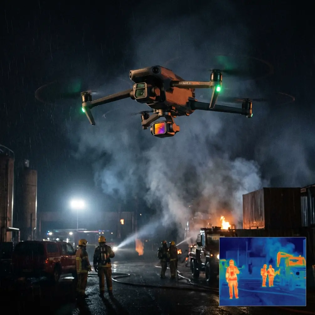
Obstacle avoidance matters more near power infrastructure than many pilots admit
Let’s start with the obvious feature: obstacle avoidance.
In a power line survey, obstacle avoidance is not permission to fly carelessly around energized infrastructure. It is a second layer of protection when terrain, vegetation, and changing perspective compress your reaction time. Complex terrain creates visual traps. A branch line on a side slope can appear farther away than it really is. A ridgeline pass can push the aircraft closer to treetops while your attention is on framing a tower. Even experienced pilots can become task-saturated.
That is why obstacle sensing has real value here. Not as an autopilot fantasy, but as risk reduction.
The operational significance is simple: when the aircraft is tracking alongside a corridor and the pilot is dividing attention between composition, telemetry, and line-of-sight management, obstacle awareness can help prevent minor errors from becoming a damaged airframe or a failed mission. Around power assets, that margin matters.
I still would not trust any obstacle system to “see” every wire reliably. Thin conductors remain one of the hardest hazards for any UAV system. But in terrain with trees, embankments, poles, and changing ground elevation, avoidance technology can reduce the odds of backing into a branch or sliding into terrain during a lateral reposition. That alone can preserve mission continuity.
ActiveTrack and subject tracking: useful, but only when used with discipline
The phrase “subject tracking” usually makes people think of athletes, cyclists, or cinematic follow shots. For utility work, the more relevant question is whether tracking tools reduce pilot workload during repeated movement patterns.
With Neo 2, ActiveTrack and subject tracking can be repurposed to support certain civilian survey tasks around access corridors and maintenance vehicles. If a crew truck or utility worker route is being documented for access planning, tracking can help produce consistent corridor footage while the pilot concentrates on aircraft spacing and obstacle awareness. It can also help with visual continuity when following a right-of-way path rather than improvising every movement manually.
That does not mean you should set the drone loose and let automation solve inspection flying. Around power lines, disciplined oversight remains essential. Conductors, static lines, poles, and terrain transitions are too unforgiving for blind trust in tracking logic.
The real advantage is workload management. When a tool like ActiveTrack handles part of the framing burden, the pilot can spend more attention on safe offset distance, wind drift, and route geometry. That is the operational significance. Not convenience for its own sake, but fewer simultaneous cognitive tasks in a difficult environment.
D-Log is not just for filmmakers when sky and shadow share the same frame
Power line surveys often produce ugly contrast. White clouds, reflective hardware, dark tree cover, and shadowed tower faces all appear in the same pass. If the Neo 2 supports D-Log capture in your workflow, that is worth using when image assessment quality matters.
Why? Dynamic range control.
A standard profile may look punchier straight out of the aircraft, but high-contrast utility scenes tend to clip the sky or bury structural detail in shadow. D-Log gives you more latitude to recover subtle information in post, especially around insulators, attachment points, vegetation encroachment, and weathered hardware surfaces.
That is not an abstract image nerd point. In field review, small tonal differences can influence whether you can clearly interpret a component edge or distinguish branch intrusion against a dark background. If the terrain puts one side of the corridor in deep shade and the opposite slope in bright sun, a flatter recording profile can preserve options that a baked-in image may throw away.
For teams handing footage to analysts, the cleaner route is often to establish a repeatable D-Log workflow and normalize it in post rather than accepting whatever the default look decides to keep.
QuickShots and Hyperlapse are more useful for context capture than most survey teams realize
I know those features sound like they belong in travel content. On a utility job, though, QuickShots and Hyperlapse can serve a serious purpose if used intentionally.
QuickShots can help create fast, repeatable contextual views of structures and surrounding terrain. Before a detailed line pass, a short automated reveal can document tower placement, vegetation density, slope condition, and access path geometry. That kind of wide context is useful later when someone reviewing the inspection needs to understand not just the defect candidate, but the environment around it.
Hyperlapse has a narrower role, but still a practical one. For corridor change documentation over time, a stabilized time-compressed sequence can show movement through a right-of-way efficiently, especially when briefing teams on terrain progression, access challenges, or broad vegetation patterns. It should not replace primary inspection imagery. It can complement it.
The point is not to treat creative tools as toys. It is to repurpose them for documentation efficiency.
What Neo 2 feels like in a real power line workflow
For surveying power lines in complex terrain, I would separate the mission into three capture layers.
1. Context pass
Use a conservative route to understand terrain rise, wind behavior, and obstacle density. This is where obstacle avoidance earns trust. I want wide framing, clean telemetry awareness, and no rushed moves.
2. Corridor pass
This is the main visual run parallel to the line with careful offset distance. If I’m documenting route continuity or access movement, this is where subject tracking or ActiveTrack can reduce manual framing load, but only if the environment allows it safely.
3. Detail pass
This is fully deliberate flying. No overreliance on automation. I want stable, controlled positioning near poles, towers, insulators, or vegetation conflicts, and I want D-Log if lighting is difficult.
The Neo 2 is most compelling when it transitions cleanly between those layers without making the pilot fight menus, aircraft hesitation, or unpredictable behavior.
A battery management tip from field experience
Here is the tip I wish more pilots learned early: in complex terrain, do not treat the return threshold you use on flat ground as valid by default.
Battery planning in hills and valleys is deceptive because the route out and the route back are rarely equal in energy demand. You may descend with a tailwind along a corridor and assume you have plenty left. Then the return leg asks the aircraft to climb, face stronger wind at ridge height, and hold a less efficient path because your original line is no longer the safest one. That is how “comfortable” battery margins disappear.
My field habit is simple. I mentally split battery use into thirds, not halves.
- First third: reconnaissance and establishing safe route behavior
- Second third: primary capture
- Final third: reserved for return, unexpected repositioning, and a landing option that may not be your launch point
That reserve becomes especially valuable in complex terrain where signal, wind, and sightline can all change with elevation. If one tower span takes longer than expected or the light forces a repeat pass, I would rather end a mission early than negotiate a stressed return with too little energy in hand.
Also, let batteries rest between flights if you are cycling multiple packs in warm conditions. Heat and hurried turnarounds can quietly erode performance. Power line work tends to create a “just one more pass” mindset. Batteries do not care about your schedule.
Wind and terrain: the hidden variable behind image consistency
A drone can feel stable at launch and become far busier once it clears a ridge shoulder or drops into a valley edge. For power line survey teams, this matters not only for safety but for image usability.
Uneven wind creates small corrections that show up as jittery framing, especially when trying to keep a line component consistently placed in the frame. If the Neo 2 holds position well and transitions smoothly through gust variation, that reduces the number of marginal clips and softens the workload on the pilot.
This is another reason I like combining obstacle awareness with measured use of tracking tools. In variable terrain, the pilot is often balancing three moving targets at once: the aircraft, the subject, and the environment. Anything that reduces unnecessary control noise without surrendering oversight is welcome.
Where Neo 2 fits best for utility-oriented users
Neo 2 makes sense for teams and operators who need a nimble aircraft for visual corridor documentation, terrain-aware route capture, and flexible imaging in mixed light. Its appeal grows when the mission includes both broad environmental context and more careful component-focused passes.
If your power line workflow involves frequent travel through wooded slopes, access roads, and elevation changes, the combination of obstacle avoidance and structured capture modes can improve consistency. If your deliverables benefit from post-processed footage, D-Log becomes a meaningful advantage rather than a spec sheet decoration. If you need to document movement along a right-of-way while reducing manual framing load, ActiveTrack and subject tracking can be helpful, provided they are used conservatively.
That last part matters. Every automation feature in this category is best treated as an assistant, not a substitute for judgment.
Final take
The Neo 2 is not defined by one standout trick. Its value for surveying power lines in complex terrain comes from how its tools stack together under pressure. Obstacle avoidance adds a margin when terrain and vegetation tighten the envelope. ActiveTrack and subject tracking can lower pilot workload in carefully chosen situations. D-Log helps preserve detail in the high-contrast scenes utility work produces all the time. QuickShots and Hyperlapse, used intelligently, add context that many reports are missing.
If I were setting up a compact visual survey workflow for difficult right-of-way environments, those are exactly the kinds of features I would want available.
And if you are comparing setup options or trying to match a Neo 2 configuration to your inspection routine, you can message the team directly here: reach them on WhatsApp.
Ready for your own Neo 2? Contact our team for expert consultation.