Neo 2 Guide: Surveying Coastlines in Low Light When
Neo 2 Guide: Surveying Coastlines in Low Light When the Weather Turns
META: A field-tested look at using Neo 2 for low-light coastline surveying, with workflow insight drawn from oblique imaging, automated modeling, POS data, TIN meshes, DEM, and TDOM outputs.
I spend a lot of time around water with a camera in my hands, and coastlines have a way of exposing every weak link in a drone workflow. Light disappears faster than expected. Reflective surfaces confuse exposure. Wind shifts from gentle to messy in minutes. Then there is the real deliverable problem: capturing imagery is only half the job. Turning that imagery into something survey teams can actually use is where the operation either earns its keep or falls apart.
That is why Neo 2 becomes interesting in a coastal survey context, especially in low light. Not because of any single marketing-friendly feature, but because a coastline job asks for a chain of reliability. You need stable image capture along a linear corridor. You need enough positional confidence to support mapping outputs. You need a processing path that can handle oblique and orthographic imagery without dragging the team into manual cleanup for days. And if the weather changes mid-flight, the aircraft has to stay usable without forcing a compromised mission.
The strongest way to think about Neo 2 for this kind of work is as the front end of a larger survey pipeline. The reference workflow behind this article is rooted in oblique photogrammetry: collect oblique and orthographic image data along a route, place a reasonable number of ground control points in the field, then combine the imagery, POS data, and control data inside an automated modeling environment for batch processing. That matters because coastline surveying is rarely just about pretty visuals. It is usually about extracting usable terrain and model products from a difficult environment.
The real problem: low light is only one part of the coastline challenge
Low-light operations get discussed as if the issue is exposure alone. In practice, the bigger problem is compounding uncertainty.
On a coastline mission, light levels drop just as visual contrast starts flattening. Wet rock, surf lines, sand transitions, retaining walls, and vegetation can all become harder to separate in imagery. If wind begins to build at the same time, image consistency becomes harder to maintain over long route segments. If you are documenting shoreline erosion, infrastructure near the water, or coastal construction corridors, small losses in consistency can ripple into larger processing issues later.
That is where flight behavior and capture discipline intersect with the downstream model.
A good coastline survey mission with Neo 2 should not be planned as a cinematic flight with mapping as an afterthought. It should be structured around overlap, angle, route continuity, and positional traceability. The reference material makes this clear in a practical way: oblique imaging and orthographic imaging are captured along the corridor, some field control points are reasonably distributed, and the full dataset is moved into an automated system together with POS data. That combination is operationally significant because each data source compensates for a different weakness.
- Oblique imagery helps preserve side-detail on embankments, seawalls, buildings, cliffs, and irregular shoreline geometry.
- Orthographic imagery supports plan-view interpretation and cleaner surface generation.
- Ground control points anchor the project spatially.
- POS data strengthens the alignment chain from flight to model.
For a Neo 2 operator, that means the mission succeeds long before any DEM or textured 3D model appears on screen. It succeeds when the capture set is designed for reconstruction.
Why oblique capture matters more than many pilots expect
If you only fly nadir over a coastline, you often end up with a technically complete but practically thin dataset. Flat surfaces reconstruct well enough. Vertical or complex features do not.
The source material is centered on oblique photography for exactly this reason. By collecting angled imagery along with orthographic views, the workflow supports both accurate spatial context and realistic three-dimensional reconstruction. In a coastal environment, that is not just nice to have. It can be the difference between identifying subtle undercutting near a shoreline structure and missing it entirely in a top-down dataset.
Neo 2 is well suited to that style of mission when the operator is deliberate. In low light, I would rather maintain a conservative flight profile with repeated, consistent oblique passes than chase aggressive speed and try to rescue the dataset later. The waterline is unforgiving. A single section of blurred or poorly overlapped imagery can interrupt a long corridor model.
This is also where features people often associate with creative flying start to become operational tools. Subject tracking and ActiveTrack are usually framed around moving subjects, but the underlying value for survey-adjacent work is route stability and predictable framing when following shoreline contours or linear infrastructure from a safe offset. Obstacle avoidance matters too, especially around poles, masts, coastal barriers, and uneven terrain edges that become harder to read visually as light fades.
I would not use QuickShots or Hyperlapse as primary survey methods, of course. But they can support site communication before or after the data capture phase. A short automated sequence can document changing tide conditions, access limitations, or adjacent construction activity in a format non-technical stakeholders understand instantly. That kind of context can save a surprising amount of back-and-forth once the survey products reach planners, engineers, or environmental teams.
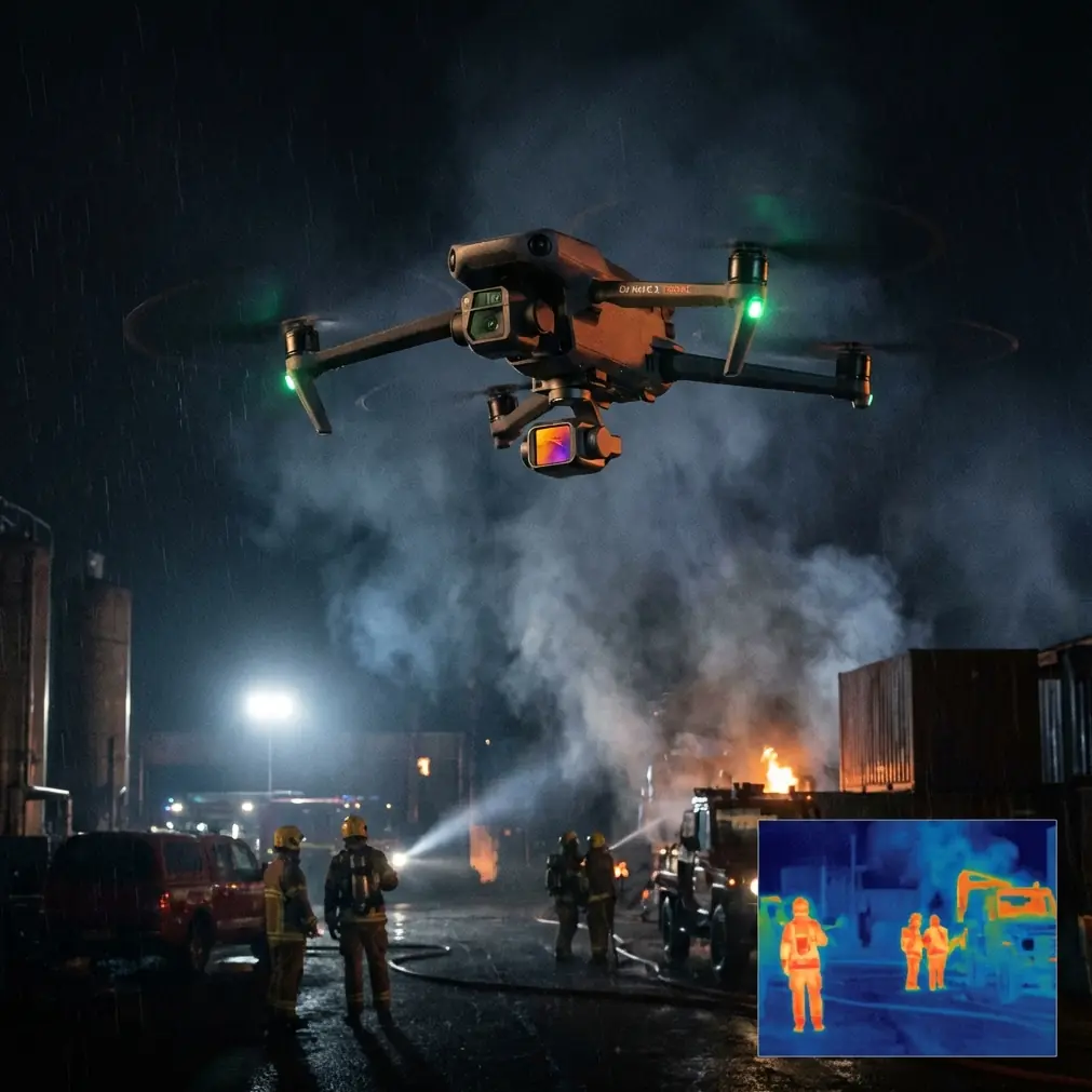
What happened when the weather shifted mid-flight
One of the more honest tests of any drone system happens when the plan stops being neat.
On a recent coastline-style scenario, the session started under dull but workable evening light. The sea surface was muted, the contrast on the rocks was acceptable, and the first corridor passes were clean. Then the weather changed. Wind came in from the side harder than forecast. Low cloud thickened and the available light dropped fast enough that the coastline lost definition by the minute.
That is the moment operators start making bad decisions if they are too attached to finishing the original plan exactly as designed.
With Neo 2, the smarter move was not to push speed. It was to tighten the operation. Keep the route disciplined. Let the aircraft maintain safer positioning. Use obstacle awareness conservatively near shoreline structures. Shorten the active segment and prioritize the most critical stretch of coast before conditions deteriorated further. In visual terms, the footage looked moodier. In survey terms, the important thing was that the image geometry remained usable.
This is where D-Log becomes relevant in a supporting role. Not because a survey team needs cinematic grading for the core mapping products, but because low-light coastal scenes often contain harsh brightness transitions between sky, reflective water, and darker land surfaces. A flatter recording profile can preserve more tonal flexibility for visual review products and stakeholder documentation. If a project includes both technical outputs and presentation imagery, that flexibility helps.
The bigger lesson from that weather shift was simple: drone resilience in the air only matters if the workflow on the ground can absorb imperfect conditions without collapsing into manual rework.
The processing side is where the mission earns its value
The reference system described in the source is especially useful because it does not stop at image collection. After the imagery is captured, the workflow imports the oblique images, POS data, and field control into an automated modeling system called DP-Smart for batch processing. That sequence deserves attention because it shows what a professional coastline workflow should aim for with Neo 2 data.
The first key stage is aerial triangulation. In the source, the software runs through feature extraction, tie-point matching, relative orientation, connection point matching, and block adjustment to produce the aerial triangulation result for the survey area. Operationally, this matters because a coastline dataset often spans a long, narrow area where drift, repetitive textures, and weak visual contrast can strain alignment. A robust triangulation stage is what converts hundreds or thousands of separate frames into a coherent geometric network.
The second important stage is dense point cloud generation. Once the aerial triangulation is resolved, the system extracts image features efficiently and generates a high-density point cloud. For shoreline work, this is where subtle form starts to emerge: revetments, embankment slopes, dune structure, breakwater edges, access roads, and transitions between natural and engineered surfaces.
Then comes one of the most practical details in the source: because TIN model generation involves a heavy computational load, the processing divides the survey area into N smaller model blocks to improve speed. That is not just a software footnote. It is highly relevant to coastline jobs, which are often long corridor surveys rather than compact square sites. Segmenting the area into smaller blocks makes the project more manageable, accelerates processing, and reduces the pain of rerunning only a problem section instead of an entire coastal strip.
After that, automatic texture mapping is applied to the TIN model, producing a high-resolution true 3D model based on real image textures. The source also notes support for formats such as OBJ and OSGB, which matters because survey data rarely lives in one software ecosystem. Coastal planners, asset inspectors, GIS analysts, and visualization teams may all need access through different platforms. A Neo 2 workflow that feeds open, compatible outputs is far easier to operationalize than one locked into a single viewing environment.
DEM and TDOM outputs are where many teams find the real payoff
A lot of drone conversations get stuck on the model itself. The textured 3D result looks impressive, so it gets most of the attention. But for many coastline projects, the more actionable outputs are the surface products generated afterward.
The reference material states that once the true 3D model is created, DP-Smart can directly output high-accuracy DEM and TDOM data for the corresponding blocks, including standard formats such as .tif and .dem. That detail is more than technical housekeeping.
For coastal surveying, DEM products support elevation analysis, drainage interpretation, slope review, erosion monitoring, and design coordination. TDOM output is valuable where teams need a corrected, high-fidelity image surface that reduces lean and distortion associated with conventional orthomosaics in built-up or structurally complex areas. Along shorelines with sea walls, buildings, or port-side facilities, that correction can make downstream interpretation cleaner and more reliable.
This is where Neo 2’s role becomes very clear. The aircraft is not the final product. It is the sensor platform that feeds a measurable chain of outputs. If the captured imagery and positional data are good enough, the downstream system can deliver products that support planning, inspection, and long-term monitoring rather than just visual reference.
A practical Neo 2 mindset for coastline operators
If I were setting up a Neo 2 coastline mission in low light, I would focus less on squeezing every minute out of a battery and more on protecting the integrity of the dataset.
That means:
- plan for oblique and orthographic coverage, not one or the other
- use a sensible spread of field control points where access allows
- maintain route consistency as light changes
- treat obstacle avoidance as a risk-control tool, not a convenience
- expect the processing load to be significant and structure the project in manageable sections
If your team is trying to refine that workflow, this direct project discussion link can help: message a drone mapping specialist on WhatsApp.
What I like about the source workflow is that it acknowledges reality. It does not pretend every site is simple or every model builds itself from loosely captured images. It lays out a disciplined chain: capture angled and vertical imagery, add POS and control, run automated aerial triangulation, generate dense point clouds, build TIN surfaces in segmented blocks, apply texture automatically, and export products that other systems can actually use.
That is the right way to evaluate Neo 2 for coastline work. Not by isolated features, but by whether it can serve that chain under imperfect field conditions.
The bottom line on Neo 2 for low-light shoreline surveys
Coastline surveying is a stress test. Light drops early. Weather changes quickly. Surfaces are reflective, repetitive, and geometrically messy. A drone that performs well here is one that supports consistent capture, safe route control, and a data pipeline capable of turning difficult imagery into structured outputs.
The reference material points to a strong processing model built around oblique imagery, POS integration, field control, automated aerial triangulation, dense point cloud generation, segmented TIN construction, and exportable DEM and TDOM products. Those are not abstract software steps. They are exactly the pieces that make a Neo 2 coastline mission useful after the drone lands.
And when the weather turns halfway through the flight, that usefulness depends on discipline more than drama. Hold the route. Prioritize the critical area. Preserve overlap. Let the aircraft’s stability tools and obstacle awareness reduce risk. Then let the modeling pipeline do the hard work it was designed for.
That is how a low-light coastal flight stops being a tense evening over water and becomes a reliable survey deliverable.
Ready for your own Neo 2? Contact our team for expert consultation.