Expert Monitoring With Neo 2: A Practical Field Workflow
Expert Monitoring With Neo 2: A Practical Field Workflow for Power Lines in Complex Terrain
META: Learn how to use Neo 2 for power line monitoring in steep, obstructed terrain, with a practical pre-flight, flight, and imaging workflow focused on obstacle avoidance, tracking, and clean capture settings.
Power line inspection in broken terrain is where small drone mistakes become expensive habits. Ridge lift changes aircraft behavior. Tree lines interrupt sightlines. Narrow access roads tempt rushed launches. If you are planning to use the Neo 2 for monitoring distribution lines, poles, and adjacent right-of-way corridors, the real advantage is not just portability. It is how quickly you can move from access point to access point while still collecting stable, reviewable footage.
That only happens if the aircraft is set up deliberately.
I would start with one step that gets skipped far too often in the field: cleaning the sensors before takeoff. On a platform that depends on obstacle avoidance and tracking intelligence, a smudge is not cosmetic. It changes how confidently the aircraft reads branches, conductors, poles, and the irregular geometry you get in gullies or on side slopes. If your mission involves flying along utility corridors where a single route may include open spans, vegetation encroachment, and sudden elevation shifts, clear forward and downward sensing matters operationally. Wipe the vision sensors and camera glass with a proper lens cloth before every sortie, especially if the aircraft came out of a dusty truck bed or a damp case at dawn.
That sounds minor. It is not. A dirty sensor can degrade obstacle avoidance behavior right when the aircraft is threading past tree edges or adjusting over uneven ground. For line monitoring, that is exactly where confidence in the flight envelope matters most.
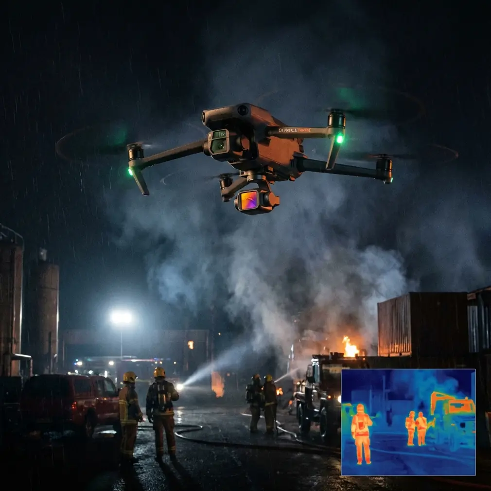
Why Neo 2 fits this job
The Neo 2 makes sense for this kind of work when the terrain punishes larger, slower-to-deploy systems. Think of short flights from multiple launch points rather than one long operation from a perfect clearing. In utility work, the bottleneck is often not flying time alone. It is repositioning, confirming line-of-sight, checking clear departure space, and deciding whether the next segment is better approached uphill, downhill, or cross-slope.
A compact aircraft helps you stay mobile, but the useful part is the stack of flight aids around that mobility. Obstacle avoidance reduces workload in areas with branches, guy wires, and uneven approach paths. ActiveTrack and subject tracking can help when you want the aircraft to maintain a consistent relationship to a vehicle or a walking inspector moving below the line. QuickShots are not a substitute for inspection passes, but they can help generate fast context footage around a structure or a span crossing for briefing, documentation, or stakeholder review. Hyperlapse is not for defect identification, but it can be useful when you want to show corridor progression over time or summarize route conditions across a longer segment.
The mistake is treating these as flashy extras. In power line work, each one has a narrow but real use case when used with discipline.
Start with the route, not the drone
Before powering on, define what the sortie needs to answer.
Are you checking for vegetation intrusion near a hillside span? Looking for hardware anomalies on poles along a winding access road? Documenting erosion around a structure foundation? Verifying whether a previously reported issue can be seen from a safer offset rather than a close manual approach?
That answer determines your flight geometry.
For complex terrain, I prefer to break a route into short sections with one objective per section. One launch for one ridgeline crossing. One launch for one steep descent. One launch for one obstructed pole cluster. That reduces the temptation to stretch battery margins or push into deteriorating line-of-sight simply because the aircraft is already airborne.
If you are building an internal field checklist and want a second pair of eyes on the workflow, you can share it directly with a remote ops contact through this field coordination link before the first launch.
The pre-flight sequence that actually matters
A clean and repeatable pre-flight routine is what separates usable data from a folder full of shaky, incomplete clips.
First, inspect the aircraft body, props, and gimbal area. Complex terrain often means launching from improvised surfaces: gravel pullouts, muddy shoulders, rocky clearings. Debris around the gimbal or micro-damage on a prop can show up later as vibration or unstable footage.
Second, clean the camera lens and the obstacle sensing surfaces. This is especially relevant after transport through dust, light rain residue, or pollen-heavy vegetation corridors. A single fingerprint on the front element can soften contrast enough to hide smaller details on insulators, crossarms, or conductor attachment points. A hazy vision sensor can also reduce how consistently the aircraft interprets nearby obstacles.
Third, verify home point logic. In uneven terrain, home point placement needs more thought than it does in an open field. Do not set up in a place that gives you a poor vertical departure path or limited GNSS confidence. If the launch point is in a cut, under trees, or near a slope break, move. A few extra steps on foot are cheaper than a compromised return profile.
Fourth, check your imaging setup before takeoff, not after the first pass. If your goal is analysis rather than casual viewing, D-Log is worth considering when lighting is uneven across a valley or when the line alternates between bright sky background and dark forest backdrop. That wider grading flexibility can help preserve detail that would otherwise clip or crush. But it only helps if your team is prepared to process it properly. If the footage needs to be reviewed quickly in the field by non-editors, a more direct color profile may be more practical.
Finally, confirm obstacle avoidance behavior in the app and think through what it cannot see well. Power lines themselves are thin visual elements. Even with modern sensing, you should not assume conductors will be recognized as robustly as larger objects like trunks, poles, or terrain faces. Obstacle avoidance is workload reduction, not permission to fly casually near energized infrastructure.
Flying the line in broken terrain
Once airborne, the best habit is to keep the aircraft offset from the line rather than directly on top of it. That gives you better visual separation between the infrastructure and the background, and it also reduces the tendency to tunnel into the route. In a steep valley, flying slightly lateral to the corridor can make it easier to read pole alignment, sag consistency, vegetation proximity, and access conditions in the same frame.
Use slower, deliberate passes near areas where terrain changes quickly. Updrafts and rotor-like effects near ridge edges can push a light aircraft off the expected path. This is where clean obstacle sensors and conservative stick inputs pay off. If the Neo 2 needs to make a minor correction while moving along a wooded edge, you want the aircraft reading the environment as clearly as possible.
ActiveTrack can be useful when an inspector or maintenance vehicle is moving under the corridor and you want a consistent aerial reference. Operationally, that matters because it lets the pilot focus more on maintaining safe stand-off and route awareness while the aircraft keeps the subject framed. But use it selectively. In dense terrain, automatic tracking can become less reliable if the subject passes under canopy edges, around terrain folds, or near visually confusing backgrounds. It is a tool, not the mission commander.
For structure-specific documentation, QuickShots can provide a fast orbital or reveal-style clip around a pole site or substructure-adjacent area. The value here is not cinematic flair. It is context. A short automated movement can show how a pole sits relative to slope angle, nearby vegetation, access path condition, and neighboring spans in one compact sequence. That can be useful for teams reviewing the site later without returning in person.
Hyperlapse is more niche, but there is a legitimate utility angle. When you need to communicate corridor progression over a longer route section, or illustrate changing terrain constraints from one access point to the next, a controlled time-compressed sequence can summarize the environment efficiently. It is best treated as supplemental documentation, not the primary inspection record.
Camera decisions that improve inspection value
Power line monitoring is usually a visibility problem before it is a flight problem. If the footage does not preserve separation between line hardware and the background, you have to fly more passes to get the same answer.
Try to avoid framing conductors against bright midday sky whenever possible. Shift your angle so poles, attachments, and nearby vegetation create contrast behind the area of interest. On side slopes, this often means flying lower and offset rather than climbing for a dramatic top-down shot. High-angle footage may look orderly, but it can flatten spacing and hide depth cues that matter when assessing encroachment or alignment.
D-Log is particularly useful when the scene contains both deep shadow and bright reflective surfaces. Utility corridors in mountainous or heavily wooded terrain often produce exactly that mix. One section may be in hard sun while the next is under dark canopy shadow. A flatter capture profile can preserve more recoverable detail across those extremes. The operational significance is straightforward: fewer reshoots because the detail survived the lighting contrast.
Even so, consistency matters more than chasing perfect aesthetics. Use settings your team can review reliably. The best footage is the footage that answers the maintenance question on the first pass.
Obstacle avoidance: useful, not magical
Obstacle avoidance deserves a realistic framing in utility work. It is highly valuable around branches, trunks, embankments, and rocky terrain features. In those environments, it reduces pilot burden and adds a margin when the route demands attention in multiple directions.
But power infrastructure introduces thin, repetitive, visually complex elements. Conductors, guy wires, and small fittings are not the same as a wall or a tree. The safest operating mindset is to assume obstacle avoidance helps with the environment around the line, not the line itself. That distinction changes behavior. You maintain wider standoff. You do not rely on automation for close inspection geometry. You use intelligent aids to stabilize the mission, not to replace judgment.
This is also why the cleaning step matters so much. If you are already dealing with a sensing problem that is inherently difficult around fine infrastructure, there is no reason to stack the odds against yourself with dusty or smeared sensors.
A simple field workflow that holds up
For most Neo 2 power line monitoring tasks in complex terrain, this sequence works well:
Launch from a clean, open point with a clear vertical departure path. Climb to a conservative height that preserves separation from nearby obstacles. Approach the corridor from the side, not directly into it. Make one slow establishing pass to understand wind, terrain effect, and visual clutter. Then perform a second pass focused on the actual issue: vegetation, hardware, slope stability near the base, or route access. If needed, add a short context clip using QuickShots. If lighting is difficult, capture in D-Log so the detail remains salvageable in review.
After landing, review immediately while still on site. Do not assume you “probably got it.” In utility operations, a missed detail discovered later means another drive, another setup, another flight window.
That is the real strength of a small aircraft like the Neo 2 in this role. It is not just that it can fly. It is that it can be deployed repeatedly, from awkward terrain, with enough intelligence to reduce pilot workload while still respecting the limits of automation.
Use the smart features. Just do not hand them the whole job.
Ready for your own Neo 2? Contact our team for expert consultation.