Neo 2 Case Study: Mapping Urban Solar Farms When
Neo 2 Case Study: Mapping Urban Solar Farms When the Weather Turns
META: A field-tested Neo 2 case study on mapping urban solar farms, covering obstacle avoidance, flight planning, wind response, subject tracking, D-Log workflows, and mid-flight weather adaptation.
Urban solar mapping looks simple on paper. Fly a grid, capture the site, process the imagery, deliver the model. In practice, city rooftops and compact solar installations punish lazy planning. Wind spills around parapet walls. HVAC units create turbulence. Glare off glass and panel surfaces can confuse both pilots and cameras. Add a weather shift in the middle of the mission and the difference between a clean dataset and a wasted afternoon comes down to how the aircraft behaves under pressure.
That is exactly where the Neo 2 becomes interesting.
This case study is built around a common real-world assignment: documenting and mapping a solar farm in an urban environment, where access is tight, vertical obstacles are everywhere, and the client needs more than pretty footage. They need usable visual records, repeatable flight paths, and confidence that the aircraft will stay predictable when conditions stop being cooperative.
Chris Park, working in a creator-operator role, approached the mission with two outputs in mind. First, a mapping pass to capture the full array layout and surrounding roof context. Second, a short visual package for internal reporting, where motion clips help stakeholders understand access lanes, maintenance clearances, and shading risks from neighboring structures. That split matters, because it pushes the Neo 2 beyond a single-purpose flight. It has to behave like a utility platform and a visual storytelling tool in the same session.
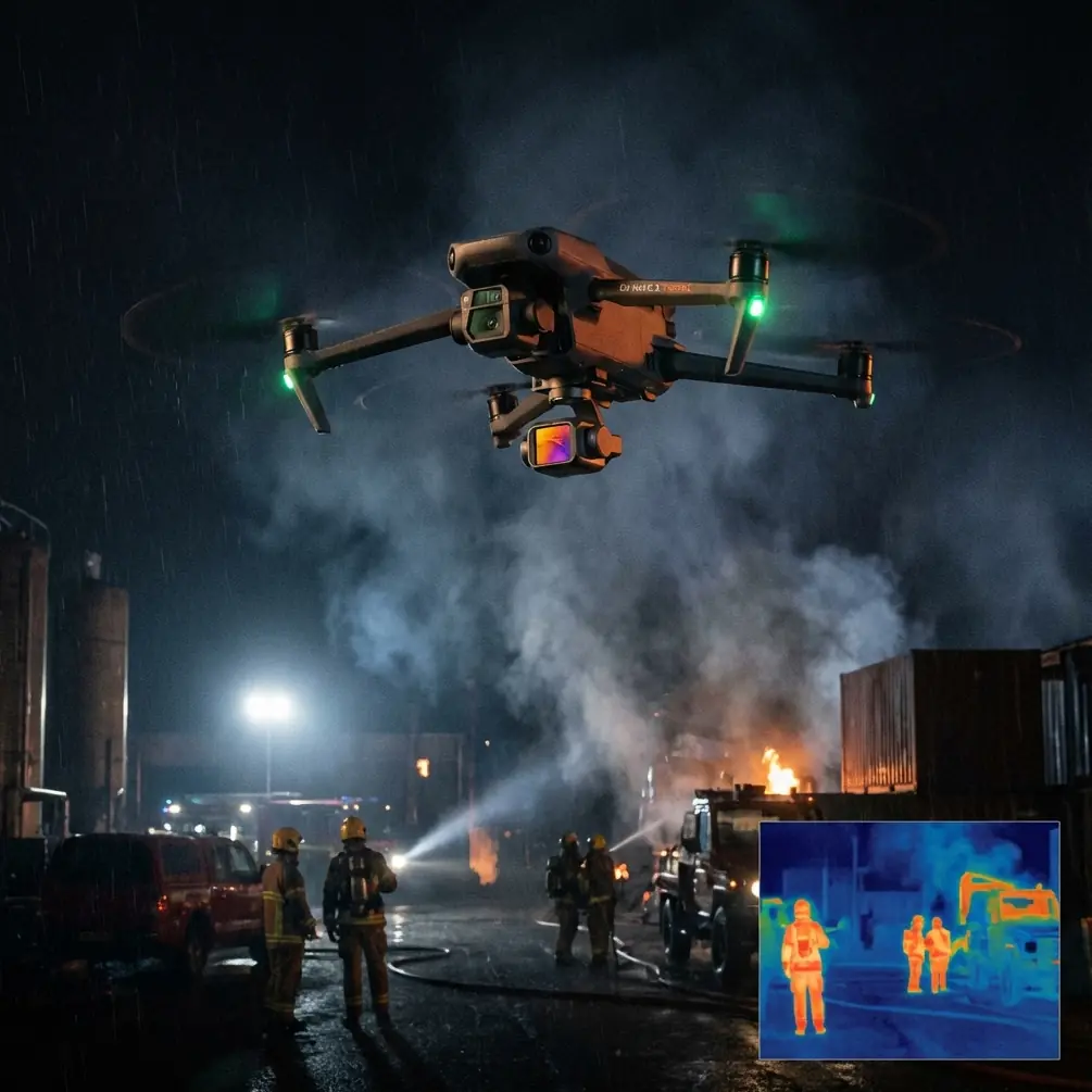
The site itself was a classic urban solar job: dense rooftop panel blocks, narrow approach corridors, metal railings, rooftop mechanical units, and neighboring buildings close enough to generate both wind disruption and signal reflections. This is where obstacle avoidance stops being a checkbox feature and becomes operationally relevant. On a broad rural site, pilots often have room to recover from a drift or abrupt stop. On a city roof, a small deviation can put the aircraft uncomfortably close to ducts, masts, cable trays, or antenna mounts.
With the Neo 2, the practical benefit of obstacle awareness is not that it removes pilot responsibility. It reduces workload at the exact moments when the pilot is already managing too many variables. While flying low passes along panel rows, Chris could focus on framing, speed consistency, and maintaining overlap rather than fighting constant micro-corrections around rooftop clutter. That matters for mapping because consistency is everything. A mission with uneven speed, erratic altitude, or interrupted lines often creates processing headaches later, especially around reflective surfaces like solar modules.
The first phase of the job was straightforward. Conditions were stable enough to run a structured capture pattern over the main panel field. The goal was not cinematic drama. It was clean geometry. Urban solar maps are valuable when they show row alignment, perimeter access, panel grouping, and surrounding obstructions in a way a facilities team can actually use. A drone that can hold a predictable line and maintain stable footage gives the operator more flexibility in post, whether the final deliverable is an inspection reference, a progress record, or a planning layer for future maintenance.
Then the weather shifted.
It started the way it often does in cities: not with a dramatic storm front, but with a subtle change in behavior. The air stopped feeling uniform. Gusts began arriving in pulses as wind redirected between buildings. Light flattened under a quick-moving cloud layer. The rooftop, which had been manageable ten minutes earlier, became noticeably less forgiving.
This is the point where a drone reveals its real character. Calm-weather performance is cheap. The harder question is what happens when the aircraft has to keep working after the environment changes.
The Neo 2 did two things well in that moment. First, it stayed controllable enough to preserve the mission. Second, it gave the pilot room to scale back intelligently instead of forcing a binary choice between full-speed continuation and immediate shutdown. That distinction matters. On many urban jobs, there is a narrow window for access, building coordination, and safe takeoff location. Losing the whole mission can mean rescheduling crews, permits, or rooftop escorts. A platform that remains predictable through a moderate shift in wind can save more than flight time; it can preserve the entire project timeline.
Chris adjusted the profile rather than pressing on blindly. Flight speed came down. Passes were shortened. Angles were changed to reduce exposure to the strongest gust corridors between structures. The Neo 2’s handling during that transition was the operational story, not the weather itself. It remained responsive enough for controlled repositioning near obstacles, and stable enough to complete the high-priority coverage before conditions deteriorated further.
That is also where subject tracking features become more useful than many pilots expect. On paper, subject tracking and ActiveTrack sound like creator-focused tools. In a solar mapping workflow, they can support contextual documentation rather than just dynamic selfies or chase footage. Chris used tracking on a rooftop technician for a short sequence showing how personnel move through service aisles and around inverter infrastructure. This provided a visual reference that static orthographic-style coverage could not. It showed scale, access constraints, and how close routine movement comes to certain hardware zones.
Operationally, that matters because many urban solar stakeholders are not pilots, surveyors, or inspectors. They are asset managers, developers, operations leads, and facilities teams. A tracked walking sequence can communicate clearance issues faster than a stack of stills. If the aircraft can maintain reliable lock while the pilot monitors surrounding hazards, the result is footage that explains the site in human terms. Neo 2’s subject tracking helps bridge that gap between technical capture and decision-ready communication.
QuickShots and Hyperlapse also have a place here, but not as gimmicks. Used carefully, they can document environmental context around an urban solar installation. A short automated orbit or elevated reveal can show how nearby towers, billboard structures, or rooftop additions affect sun access and maintenance approach paths. A Hyperlapse sequence, especially when weather is changing, can visualize moving shadow patterns or cloud transitions across the panel field. That kind of clip is not a substitute for irradiance analysis, of course, but it is valuable for presentations and site reviews where non-technical stakeholders need to see why a location behaves the way it does over time.
The weather change also affected imaging choices. Bright panel reflections under partial cloud can create ugly contrast swings. This is one reason D-Log matters in a workflow like this. Flat color profiles are often discussed in cinematic terms, but their practical value on reflective infrastructure jobs is broader. When the scene shifts quickly from hard highlights to muted overcast, D-Log preserves more flexibility for recovering detail and balancing footage across the sequence. On a solar site, where reflective surfaces can clip quickly and dark roof materials can disappear into shadow, that extra grading latitude helps maintain consistency in the final deliverable.
That does not mean every operator should default to a stylized post-production workflow. It means the Neo 2 gives a skilled pilot-editor a safer margin when the lighting refuses to behave. In this case, footage captured before and after the cloud shift could be matched more cleanly, which kept the client package coherent. That is a small technical detail with a large communication payoff. When a report looks visually fragmented, clients start questioning the reliability of the capture itself, even if the underlying data is sound.
Another overlooked factor in urban solar mapping is pilot attention management. The mission is rarely just about flying. You are checking roof boundaries, maintaining visual awareness around people, watching for birds, noting reflective glare, tracking battery timing, and adapting to wind that behaves differently at each corner of the structure. Features like obstacle avoidance, ActiveTrack, and automated flight assists are most valuable when they free up mental bandwidth. Not because they replace skill, but because they reduce the number of things demanding equal attention at once.
That was clear once conditions worsened. Instead of trying to salvage every optional shot, Chris prioritized the essential mapping coverage, then used a short controlled sequence to capture supporting visuals near the technician path. This is the kind of discipline that separates productive flights from chaotic ones. The Neo 2 supported that decision by staying composed enough to finish the important work without introducing drama of its own.
There is also a broader lesson here for anyone mapping solar farms in built-up areas: urban missions reward adaptability more than raw speed. A drone that launches fast but becomes awkward around complex structures is less useful than one that can transition between mapping, contextual documentation, and controlled close-environment flight. Neo 2’s appeal in this scenario is not one single feature. It is the stack. Obstacle avoidance supports low-altitude work near rooftop hardware. Subject tracking and ActiveTrack help turn technical sites into understandable visual stories. QuickShots and Hyperlapse add context when used with restraint. D-Log protects footage quality when light changes faster than the schedule.
If you are planning a similar workflow and want to compare notes on mission setup, payload expectations, or rooftop risk management, you can reach out here: https://wa.me/example
For solar professionals, creators, and drone operators, the real takeaway is simple. Mapping an urban solar farm is not just a geometry exercise. It is a live negotiation with space, light, airflow, and stakeholder expectations. The aircraft has to support precision, but it also has to help explain the site to people who will never touch the controls.
On this mission, the weather shift became the defining test. Not because it was extreme, but because it exposed the small behaviors that make or break field confidence. The Neo 2 handled the mid-flight change with enough stability to preserve the deliverable, enough awareness to stay comfortable around rooftop obstacles, and enough imaging flexibility to keep the final package usable after light conditions moved around.
That is what good drone performance looks like in the real world. Not isolated specs. Not perfect-weather demos. A rooftop, a solar array, a schedule, a sudden wind change, and a pilot who still comes back with something the client can use.
Ready for your own Neo 2? Contact our team for expert consultation.