Neo 2 in Remote Highway Mapping: Why Model Repair Matters
Neo 2 in Remote Highway Mapping: Why Model Repair Matters More Than the Flight Itself
META: A field-tested look at using Neo 2 for remote highway mapping, with emphasis on photogrammetry workflow, DP-Modeler mesh repair, handheld and vehicle image补充 capture, and practical EMI antenna adjustment in difficult terrain.
Remote highway mapping looks simple from a distance. Put a drone in the air, collect overlap, process the data, export the model. On paper, that workflow feels clean.
Out on an isolated road corridor, it rarely is.
The harder part is not always the flight. It is what happens after the mission, when a 3D reconstruction reveals the usual defects: traffic ghosts, broken road edges, thin barriers that collapse into noise, reflective water surfaces, and stretches where geometry is technically complete but visually unreliable for engineering review. That is where the reference material behind this discussion becomes unusually relevant. Pages 16 to 18 of the air-ground integrated photogrammetry solution focus on one specific step that many teams underweight: real-scene 3D model retouching in DP-Modeler, including mesh model image supplementation and fast correction using vehicle-mounted or handheld imagery.
For a Neo 2 operator mapping highways in remote areas, that detail is not cosmetic. It changes how you plan the mission, how you react to interference in the field, and how you deliver a usable corridor model when the first-pass mesh is imperfect.
The real constraint in remote corridor mapping
Highway projects in remote regions create a strange combination of freedom and fragility. You may have long, open lines of sight and fewer urban obstacles, which sounds ideal for flight operations. Yet those same environments often produce sparse logistics, unstable weather windows, intermittent signal conditions, and limited opportunities to revisit the site.
A conventional mapping mindset assumes the aircraft must capture everything perfectly in one pass. That assumption is expensive. A more resilient workflow is to use Neo 2 as the backbone of corridor acquisition, then deliberately leave room for controlled completion and repair through ground-level imagery where needed.
That is the operational significance of the source material’s emphasis on DP-Modeler real-scene 3D model retouching. It points to a workflow where the 3D mesh is not treated as sacred output, but as an editable deliverable. If a roadside guardrail, bridge edge, drainage structure, or cut slope reconstructs poorly, the answer is not always a full reflighting campaign. The workflow explicitly supports image supplementation for the mesh model, and it mentions rapid retouching using vehicle or handheld image capture. For highway teams, that is a practical advantage, not a software feature checkbox.
In a remote job, every avoided return trip matters.
Why Neo 2 fits this kind of corridor work
Neo 2 is not just interesting because it flies. It fits this scenario because remote highway mapping is a mixed-task operation. You are not only collecting nadir grids. You are also verifying terrain transitions, checking structures along the corridor, monitoring occlusion points, and documenting surface context in ways that support both model generation and stakeholder interpretation.
That is where features commonly associated with creative flight modes become surprisingly useful in industrial work. Subject tracking and ActiveTrack, for example, are not only for cinematic movement. In corridor inspection and training scenarios, they can help an operator maintain consistent observation of a survey vehicle or moving reference point along a safe route segment. QuickShots and Hyperlapse are not primary mapping tools, but they can support progress documentation and project communication when the engineering team needs a concise visual record of terrain access, road alignment, or construction staging.
Then there is D-Log. On a pure mapping brief, some teams ignore image profile choices because they assume geometry is all that matters. In practice, tonal latitude can be helpful when the site includes hard contrast transitions: dark cut sections, bright concrete, sunlit gravel shoulders, and reflective puddles or water surfaces. Better tonal control can make visual interpretation easier during QA, especially when reviewing where the model may need supplementation.
None of those features replaces a proper photogrammetry mission. They do make Neo 2 more adaptable in real project conditions.
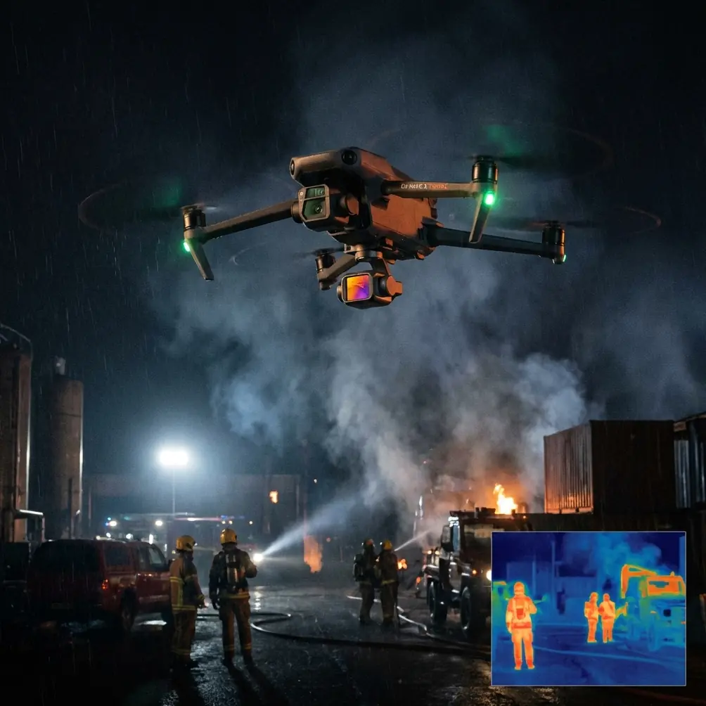
A case from the field: remote highway section with EMI problems
On one remote corridor assignment, the flight area looked benign. Sparse development. Limited vertical obstructions. A clean roadway line crossing rolling ground.
The issue was electromagnetic interference.
Remote does not always mean electrically quiet. Transmission infrastructure, roadside communications equipment, temporary construction power, and even vehicle electronics clustered near the takeoff zone can create inconsistent signal behavior. The result may not be a catastrophic loss of control. More often, it appears as unstable telemetry confidence, intermittent compass warnings, or degraded control comfort just when precise corridor alignment matters most.
This is where field discipline separates experienced operators from people who only know ideal-condition demos.
The first response is not panic. It is diagnosis.
We shifted the launch position and paid close attention to antenna orientation rather than assuming the original setup was acceptable. Antenna adjustment sounds trivial until it saves a mission. On a long highway line, the geometry between pilot, aircraft, and route direction changes constantly. If the antenna alignment is poor at the start, especially in a low-elevation corridor profile, the signal margin can become thinner than expected. Small physical changes in controller orientation can clean up a link that software settings alone will not fix.
That matters operationally for two reasons.
First, stable control and transmission reduce the temptation to compromise the route pattern. Operators under signal stress tend to shorten legs, fly higher than planned, or accept suboptimal overlap because they are trying to “get through it.” Those shortcuts show up later in the model.
Second, better link confidence gives you cleaner decision-making about where the aerial mission ends and where the supplemental ground capture begins. If a localized section near roadside infrastructure remains noisy from an acquisition standpoint, it may be wiser to complete the bulk aerial block cleanly and plan targeted vehicle or handheld capture for the affected geometry, rather than forcing a marginal airborne pass.
That is exactly where the source workflow becomes powerful.
The overlooked value of vehicle and handheld image supplementation
The reference pages specifically point toward using vehicle-mounted or handheld imagery for rapid model retouching. For highway mapping, that is one of the most sensible ideas in the entire pipeline.
Why? Because highways are linear environments full of features that aerial perspective alone does not always reconstruct well:
- vertical road edges
- underrepresented side faces
- barriers and signage
- culverts and drainage openings
- bridge approaches
- embankment transitions
- narrow roadside assets
- reflective or low-texture surfaces
A drone can capture the corridor efficiently, but the viewpoint geometry is still biased from above. Ground supplementation closes that gap.
If your Neo 2 mission produces a strong base mesh over several kilometers, but one interchange, service bay, or drainage crossing comes out weak, a short vehicle-based image run can provide the missing visual coverage. Likewise, handheld capture is often the fastest fix in places where stopping a vehicle is easier than relaunching the drone, or where close-range perspective is needed around complex roadside details.
This is not a patch for poor planning. It is an integrated strategy.
The significance of the source document is that it frames retouching as part of the solution, not as a failure response. That distinction matters. Teams that normalize mesh refinement produce more reliable deliverables than teams that assume first-pass reconstruction should be flawless.
What model repair actually changes for deliverables
A repaired model is not just prettier.
It is more useful.
When the source material references before-and-after model modification comparison, that implies a measurable improvement in interpretability. In highway applications, interpretability affects downstream decisions. A corridor model may be used to review slope conditions, access paths, surrounding terrain constraints, roadside asset placement, and construction context. If the mesh is torn, noisy, or missing critical edges, planners and engineers either lose confidence or waste time verifying obvious defects manually.
Even a seemingly minor issue like a broken road shoulder or malformed barrier can create friction in meetings. People start questioning the whole dataset. Once that happens, the model stops functioning as a decision tool and becomes a discussion about data quality.
That is why DP-Modeler-style retouching deserves more attention in Neo 2 project design. The ability to supplement imagery and quickly refine a real-scene mesh helps protect the credibility of the final output.
And there are known problem surfaces that make this especially relevant. One visible clue in the source is water surface handling. Water is notoriously difficult in photogrammetry because reflection, transparency, and low texture can confuse reconstruction. Remote highways often cross ponds, drainage channels, reservoirs, or flooded shoulders. If your model includes these areas, expecting perfect geometry from aerial capture alone is optimistic. A workflow that anticipates correction is simply more mature.
A smarter mission architecture for Neo 2 highway work
If I were structuring a Neo 2 workflow around the source material, I would not think in terms of one flight and one processing run. I would think in layers.
1. Primary aerial corridor capture
Use Neo 2 to establish the main spatial framework of the highway section. Maintain conservative overlap and fly with signal discipline, especially in areas with suspected electromagnetic disturbance. If EMI appears, reassess launch position and antenna direction before blaming the aircraft or rushing the route.
2. Defect identification during preliminary processing
Do not wait until final delivery to inspect the model. Process early enough to identify weak zones while the team is still near the site or still has logistical access.
3. Ground-level supplementation
Where the mesh is incomplete or unreliable, capture supplemental images from a vehicle or on foot. The reference explicitly supports this. For remote roads, that can save an entire repeat aerial mission.
4. DP-Modeler retouching
Use the supplemental imagery to repair the real-scene 3D mesh. This is where the workflow moves from data collection to data usability.
5. Context deliverables
Leverage Neo 2’s broader imaging capability for stakeholder communication. D-Log footage can support review under difficult lighting. Hyperlapse or selected automated movement captures can help summarize access conditions or progress without affecting the core survey dataset.
That layered approach is more forgiving, and in remote mapping, forgiveness is efficiency.
What this means for teams choosing process over perfection
The best highway mapping teams are rarely the ones with the most dramatic flight videos. They are the ones that understand where data fails and build recovery paths into the workflow.
The source material is valuable because it quietly exposes a truth many UAV operators learn late: photogrammetry quality is not decided only in the sky. It is decided in how intelligently you supplement, diagnose, and repair. DP-Modeler’s real-scene 3D model retouching, together with mesh image supplementation through vehicle or handheld capture, gives Neo 2 teams a way to keep corridor projects moving even when the first model is incomplete.
For remote operations, that can be the difference between a deliverable this week and a site return next month.
It also changes how you brief clients and internal stakeholders. Instead of promising magic from a single flight, you can promise a controlled production method: aerial acquisition for efficient coverage, targeted ground capture for weak geometry, and structured mesh refinement to produce a model that stands up to review.
That is a more honest workflow. It is also a better one.
If your team is working through similar corridor mapping challenges and wants to compare field workflow options, you can message Chris Park directly here.
Neo 2 is often discussed in terms of flight convenience and creator-friendly features. Those matter, but for remote highway mapping, the bigger story is workflow resilience. When interference forces antenna adjustments, when corridor geometry exposes reconstruction limits, and when water surfaces or roadside details break the mesh, the mission does not end at data import. That is where the real work begins.
Ready for your own Neo 2? Contact our team for expert consultation.