Neo 2 for Highway Inspection in Complex Terrain
Neo 2 for Highway Inspection in Complex Terrain: What Actually Matters in the Data Workflow
META: A field-focused look at using Neo 2 for highway inspection in difficult terrain, with practical insight into LiDAR-style post-processing logic, sensor alignment, and why trajectory discipline changes results.
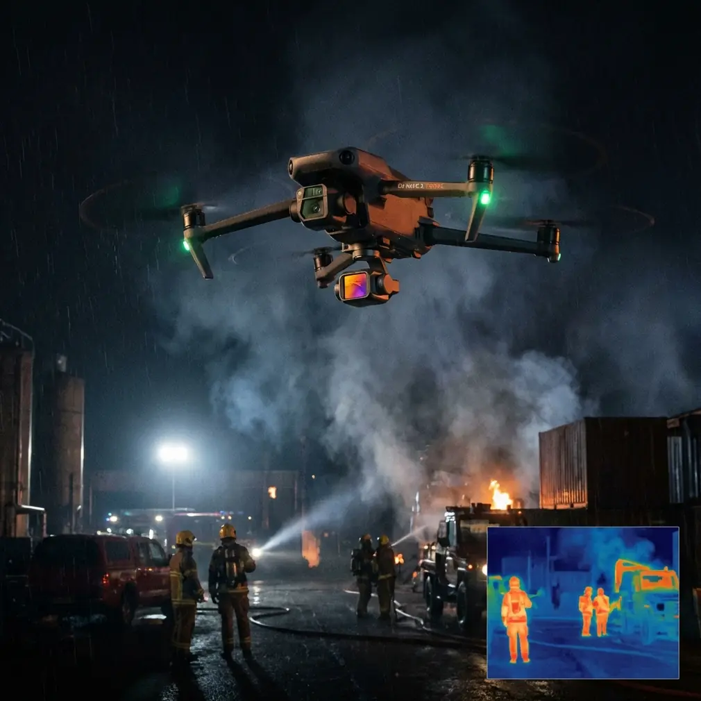
Highway inspection gets messy the moment the terrain stops cooperating.
On paper, the mission sounds simple: follow a corridor, document slopes, barriers, drainage features, pavement edges, and risk points around bridges or cut sections. In practice, mountain roads, deep embankments, vegetation, unstable GNSS conditions, and constantly shifting sightlines turn a routine flight into a data-quality problem. I learned that the hard way on a corridor job where the aircraft flew fine, the imagery looked fine, and yet the final deliverable still took too much cleanup because the trajectory and sensor timing discipline were not tight enough.
That experience changed how I think about compact drone platforms like Neo 2.
Most people looking at Neo 2 for highway work focus on obvious flight features first: obstacle avoidance, subject tracking, QuickShots, Hyperlapse, D-Log, ActiveTrack. Those can help, especially in visual documentation and repeatable corridor capture. But the deeper operational lesson comes from a powerline LiDAR workflow reference that highlights something many inspection teams still underestimate: the quality of the result is shaped as much by post-processing structure and sensor alignment as by what happened in the air.
For highway inspection in complex terrain, that matters more than almost anything else.
The old headache: good flights, weak spatial consistency
Years ago, one of the recurring problems on corridor inspections was not getting the drone through the mission. It was stitching the mission into something dependable afterward.
You might fly a mountain road section with steep slopes on one side and a drop-off on the other. The aircraft tracks the route. The camera collects everything you asked for. ActiveTrack or intelligent follow behavior can reduce pilot workload when moving along a linear feature. Obstacle avoidance adds confidence near trees, sign structures, retaining walls, and cut slopes. For visual review, that already feels like a win.
Then the office work starts.
Suddenly, the questions are more serious:
- Did the trajectory remain stable enough through the full corridor?
- Did the timing between navigation data and image or scan data stay coherent?
- Can repeated passes over the same road segment be compared without drift?
- Will a slope crack, drainage deformation, or barrier offset appear in the right location relative to the roadway centerline?
This is where the reference material becomes useful, even though it comes from a powerline LiDAR solution rather than a highway article. Its core message transfers directly: data integrity depends on disciplined acquisition order, reliable post-processing, and a unified spatial and temporal framework across sensors.
That is not theory. That is what separates an attractive flight record from a usable inspection dataset.
Why the reference workflow deserves attention
One detail in the source stands out immediately. It defines a complete raw-data acquisition sequence as:
initial alignment -> accuracy convergence -> survey area acquisition -> accuracy convergence -> initial alignment
That is more than a procedural footnote. It is an operational safeguard.
The source also explains why this sequence is repeated in reverse after the survey section: the post-processing software supports both forward and backward solutions, and combining those two directions improves accuracy. To support backward processing successfully, the operator must repeat the convergence and initialization steps after completing the target area.
For highway inspection teams, the implication is clear.
If you only think about the “main run” over the road, you are treating the job too casually. The route itself is just one segment inside a broader data-capture envelope. The lead-in and lead-out portions are not wasted time. They help stabilize the navigation solution before and after the critical section, which makes the corridor result more trustworthy.
That is especially relevant in complex terrain where satellite geometry can fluctuate, tree cover can interrupt signal quality, and rapid changes in elevation or vehicle positioning can challenge inertial estimation. Neo 2 operators working in these environments should think less like casual content creators and more like corridor survey technicians. Even if the mission output is primarily visual rather than full LiDAR mapping, the same discipline improves repeatability.
The 30-minute rule is not just a number
Another concrete detail from the reference is easy to overlook: raw data collection for the base station and mobile station should occur simultaneously, and the minimum acquisition time is half an hour. Just as important, the base station’s recording window must fully cover the mobile platform’s recording window. In other words, the mobile data should start later than the base station and end earlier than the base station.
Operationally, this is huge.
On a highway inspection mission, especially one spread across winding terrain, teams often rush setup because the visible task is the road segment itself. But if your positioning framework starts late or ends too early, you reduce the value of the entire mission. The source is basically reminding us that reliable correction depends on overlap. The supporting data must fully bracket the airborne data.
For Neo 2 users, even if the mission is not a formal LiDAR corridor survey, this principle still improves habits. Good corridor inspection begins before takeoff and ends after landing. Timing discipline creates cleaner alignment between aircraft movement, captured imagery, and any downstream geospatial interpretation.
That is one of the quiet reasons compact platforms have become more useful in infrastructure work. A model like Neo 2 lowers deployment friction, which makes it easier to preserve operational discipline instead of skipping steps. When setup is simpler, teams are more likely to run proper prep, maintain a consistent capture rhythm, and repeat flights under comparable conditions.
Post-processing is where “inspection” becomes evidence
The source outlines the POS data workflow in a sequence that includes:
- raw data conversion
- GNSS solution
- GNSS/INS integrated solution
- smoothing
- output results
This order tells a story.
A lot of highway inspection programs still rely heavily on visual review alone. That has value, especially for identifying loose guardrails, vegetation encroachment, blocked drainage, or rockfall signs. But in difficult terrain, the real advantage comes when flight data is processed into something spatially stable enough to revisit over time.
The smoothing step in particular deserves more respect. Raw navigation output can be noisy. Integrated GNSS/INS processing helps reconcile satellite and inertial behavior. Smoothing then refines the trajectory further. For corridor inspections, that matters because linear assets expose inconsistency brutally. A bridge parapet, lane edge, median barrier, or slope bench should not appear to wobble from one segment to another due to weak trajectory refinement.
Neo 2 is attractive because it can capture fast, repeatable visual passes without the operational heaviness of a larger survey aircraft. But if the goal is professional highway inspection rather than casual review, the data should be handled with the same respect described in the reference workflow: solve it, integrate it, smooth it, and only then trust it.
Why unified coordinates and time sync matter on a road corridor
The most transferable lesson from the reference appears in its LiDAR360 section. It states that to process laser measurement data in real time or in post, the system must have a unified spatial reference and a unified time reference. It then describes bringing the origins of GPS, IMU, and LiDAR into one base coordinate system and putting all sensor data into the same time-coordinate framework.
That is the backbone of corridor credibility.
On a highway, you are not inspecting isolated points. You are evaluating relationships:
- the slope relative to the shoulder
- the drainage channel relative to the pavement edge
- the barrier line relative to embankment geometry
- cracks or settlement signs relative to structures and chainage
If different sensor streams do not agree on where and when events occurred, your interpretation degrades fast.
Even for Neo 2 users focused on imaging rather than dedicated LiDAR, the lesson still applies. Camera data, flight trajectory, and any supplementary measurements have to live inside the same spatial logic. Otherwise, comparisons between runs become weak. Subject tracking and ActiveTrack can keep a moving inspection vehicle or target corridor visually centered, which is useful in field execution. D-Log can preserve tonal detail for later inspection of concrete staining, erosion marks, or surface defects. QuickShots and Hyperlapse may support stakeholder communication by condensing long corridor sections into digestible visual summaries. But none of that replaces coordinate and timing discipline.
Pretty footage can support a report. Proper alignment can support a decision.
How Neo 2 changes the field routine
The real value of Neo 2 in complex highway terrain is not that it eliminates workflow rigor. It is that it makes rigor easier to maintain.
On older jobs, one challenge was simply cognitive overload. The pilot was managing route geometry, terrain awareness, visual line of sight, traffic-adjacent hazards, lighting shifts, and obstacle proximity all at once. Every bit of pilot attention spent on basic aircraft management was attention not spent on inspection quality.
Neo 2 shifts some of that burden.
Obstacle avoidance helps when the corridor passes near trees, sign gantries, cut slopes, utility crossings, or bridge elements. ActiveTrack and subject-tracking functions can reduce the friction of maintaining visual consistency along a road-aligned target. In practical terms, that means the operator can pay more attention to whether the mission is capturing the right inspection evidence, not just whether the drone is staying in the air.
That distinction matters.
When a platform is easier to place accurately and repeatedly, teams are more likely to adopt structured capture plans that mirror the logic of the reference workflow: stable pre-run setup, consistent corridor acquisition, controlled exit, and disciplined office processing. That is where productivity gains become real. Not in marketing language. In fewer questionable segments, fewer reflights, and cleaner comparison between inspection dates.
A smarter problem-solution model for highway teams
If I were building a Neo 2 highway inspection workflow today around the lessons in this reference, I would frame the problem and solution like this.
Problem: complex terrain weakens confidence
Mountain roads and cut-and-fill alignments create unstable conditions for corridor capture. Visual documentation alone often looks acceptable even when spatial consistency is mediocre. Teams discover the weakness later, during review or when trying to compare changes over time.
Solution: treat the mission as a data corridor, not a camera outing
The reference shows that bidirectional post-processing benefits from deliberate acquisition before and after the actual survey area. It also shows that integrated processing only works well when base and mobile data are timed correctly and when sensor origins and timestamps are unified.
Applied to Neo 2, that means:
- plan lead-in and lead-out flight logic, not just the target stretch
- keep timing discipline across the full capture window
- preserve repeatability in route geometry and altitude behavior
- process flight data with trajectory quality in mind, not just video export
- use intelligent flight aids to reduce operator workload, not to replace mission planning
That is how a small aircraft becomes part of a serious inspection workflow.
What I wish more teams understood
The best inspection operators are not the ones who collect the most footage. They are the ones who produce the fewest ambiguous findings.
This is why the reference material is so relevant. Even though it is centered on a powerline LiDAR solution, it captures a truth that highway inspectors can use immediately: integrated sensor work succeeds only when collection order, timing overlap, coordinate unification, and post-processing logic are all handled deliberately.
If your team is using Neo 2 in complex terrain, that is the mindset to copy.
Use obstacle avoidance to protect the mission in cluttered sections. Use ActiveTrack and subject tracking to keep corridor motion predictable. Use D-Log when surface interpretation benefits from better tonal latitude. Use QuickShots or Hyperlapse selectively for communication outputs. But build the whole operation on a stronger base: stable alignment, convergence before the main corridor, careful exit after it, and processing that respects the trajectory.
That is the difference between “we flew the road” and “we inspected the road.”
If you are comparing workflow options or want to talk through a practical corridor setup, you can message our UAV specialists here.
Neo 2 does not magically solve highway inspection. What it does is remove enough friction that disciplined teams can execute a better method more consistently. And once you have lived through the opposite—good-looking flights with weak downstream reliability—you start to appreciate that difference very quickly.
Ready for your own Neo 2? Contact our team for expert consultation.