Neo 2 on Mountain Solar Farms: What Actually Matters
Neo 2 on Mountain Solar Farms: What Actually Matters in the Field
META: A field-driven case study on using Neo 2 around mountain solar farms, with practical insight on vibration isolation, alpha-beta filtering, obstacle awareness, tracking workflows, and antenna positioning for stronger range.
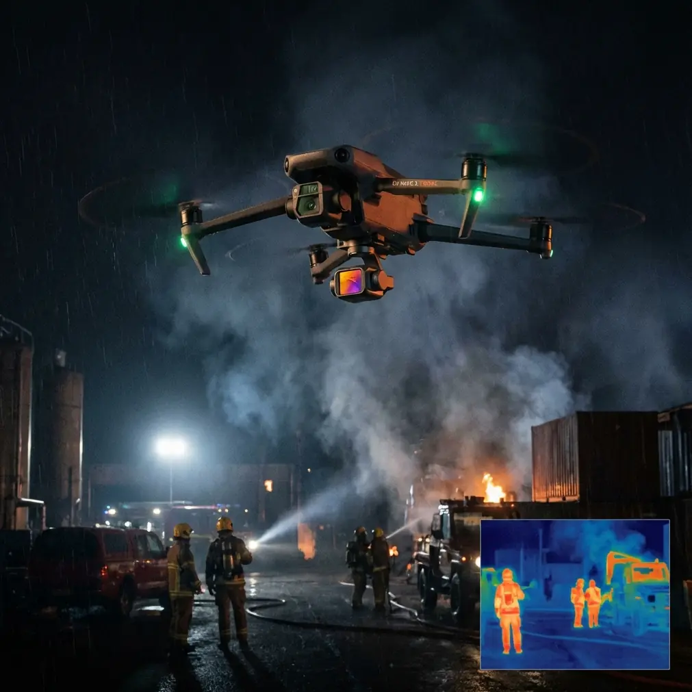
Mountain solar sites look clean and orderly from a distance. Up close, they are awkward places to fly.
The terrain folds in on itself. Access roads snake along ridgelines. Panel rows create repeating visual patterns that can confuse both pilots and sensors. Wind behaves differently every few hundred meters. If you are documenting delivery progress, checking array alignment, or building visual records for EPC teams, a small aircraft like Neo 2 can be surprisingly useful—but only if you respect the physics underneath the footage.
I’ve spent enough time around hillside projects to know that the real story is not just whether a drone has QuickShots, ActiveTrack, or obstacle awareness on paper. It is whether the aircraft can give you stable, believable visual data when mountain gusts, mechanical vibration, and line-of-sight interruptions all start stacking up at once.
That is where the engineering ideas behind vibration control and simple real-time filtering become more relevant than most buyers realize.
A practical case: documenting delivery work on a mountain solar farm
Let’s frame this around a realistic assignment.
A logistics and project documentation team needs progress footage of equipment deliveries to a solar farm built along uneven mountain benches. The brief sounds straightforward: capture truck arrivals, verify unloaded component staging, and create short clips for internal reporting and investor updates. The aircraft of choice is Neo 2 because the team wants something lightweight, fast to deploy, and capable of smooth subject tracking for moving vehicles and crews.
On a flat industrial lot, this is easy work. On a mountain solar site, it becomes a sensor and control problem.
When trucks move along winding roads cut into slopes, the aircraft has to deal with changing background contrast, sudden elevation transitions, and occasional turbulence spilling over ridges. If the drone’s sensing and stabilization chain is noisy, the result is familiar: footage with micro-jitter, unreliable tracking locks, and positional behavior that feels less confident than it should.
That is why two details from the reference material stand out.
The first is mechanical: a vibration-isolation structure using two mounting plates connected by elastic columns, with those elastic columns installed at 45 degrees. The significance is not cosmetic. A 45-degree mounting orientation helps isolate not just vertical vibration, but horizontal-plane vibration as well. For drone operations near mountain roads and exposed plant infrastructure, that matters because airframe vibration rarely arrives in a single neat axis. Rotor-induced buzz, wind buffeting, and frame resonance combine in multiple directions.
The second is computational: the use of an alpha-beta filter, a lightweight recursive filter that predicts position using velocity over a small time interval dt, then corrects that estimate using a residual. The core position prediction is shown in the source as:
- predicted position at the next step equals the prior estimated position plus estimated velocity times dt
And the correction logic uses a residual:
- r = measured position minus predicted position
Then two constants, alpha and beta, adjust the position and velocity estimates. The source notes that both constants typically sit between 0 and 1, and that their best values need to be determined experimentally.
Those two facts—45-degree vibration isolation and alpha-beta filtering with tunable gains—tell us a lot about what makes a compact drone usable in demanding terrain.
Why mountain solar work exposes every weakness in a small drone
Solar farms built on hillsides create a tricky blend of repetitive geometry and unstable airflow.
Panel fields are full of long, regular lines. That can be visually beautiful, but machine vision systems often prefer distinct, separable features. Add moving shadows from clouds or late-day sun and subject tracking has a harder job. If you are using ActiveTrack to follow a utility vehicle carrying pallets or cable reels, small tracking errors can snowball if the aircraft is already fighting noisy motion estimates.
This is where vibration isolation matters operationally, not academically.
A sensor stack mounted with proper damping sees a cleaner world. When the source document describes a system using two plates and elastic columns to isolate vibration, it is describing a first line of defense against bad data. The reason the 45-degree arrangement is worth calling out is simple: mountain-site disturbances are not purely up-and-down. Side gusts, braking corrections, and yaw adjustments all feed vibration into the frame laterally. If your isolation approach only handles vertical movement well, the aircraft may still pass enough horizontal shake into the sensing system to degrade tracking and stabilization.
For Neo 2 users, this translates into a familiar field truth: smooth output begins before software ever touches the signal.
The hidden role of filtering in “easy” flight modes
Pilots often talk about QuickShots, Hyperlapse, or obstacle avoidance as if these are separate features living on top of the aircraft. In reality, they all depend on the quality of the drone’s state estimate—where it thinks it is, how fast it is moving, and how confidently it can predict the next moment.
That is exactly the problem the alpha-beta filter is meant to address.
The source describes a simplified recursive method that assumes one state is the integral of another—classic position and velocity. Over a short interval dt, velocity is treated as constant. So the system predicts where the aircraft should be next. Then it compares that prediction with the measured result and computes the residual r. If the residual is positive, the prior position estimate may have been too low, the velocity estimate may have been too low, or both. The filter then uses alpha and beta to distribute the correction across position and velocity.
This is not an exotic lab method. Its value is that it is computationally light and has strong real-time behavior, which the reference explicitly highlights. For a compact drone working near terrain, that matters more than elegance. Real-time responsiveness often beats theoretical perfection when you are following a truck that disappears behind a panel block and reemerges seconds later.
Operationally, what does that mean for Neo 2 on a solar site?
It means a drone can remain more stable and believable in motion if its estimates are not overreacting to every noisy measurement. If the filtering is too weak, the aircraft chases noise. If too aggressive, it lags and feels detached. The source’s note that alpha and beta usually need to be tuned experimentally is especially relevant in mountain environments, where no single setting behaves best across calm dawn flights, midday thermals, and windy ridge-edge passes.
How this affects actual Neo 2 workflows
For a delivery documentation mission, I would divide Neo 2 use into three categories.
1. Close-range progress clips around unloading zones
This is where obstacle awareness and low-altitude confidence matter most. Trucks, pallets, temporary fencing, cable drums, and scaffold sections can clutter the edge of the flight path. A compact aircraft is useful here because it can be launched quickly from a safe staging point and repositioned between unloading areas without turning the operation into a full production shoot.
In these tighter scenes, vibration control becomes visible in a very direct way. If the aircraft is carrying subtle frame vibration into the sensor system, the final result looks nervous, especially when hovering beside repetitive panel rows. Better isolation means cleaner stills, smoother lateral reveals, and less wobble when using short automated moves.
2. Tracking support vehicles on mountain access roads
This is where ActiveTrack-style functions can save time, but only when the aircraft keeps a reliable estimate of motion. The alpha-beta logic from the reference helps explain why some drones feel calm in tracking mode while others seem to pulse or correct too abruptly.
Because the filter predicts position using prior velocity over dt, it is naturally well suited to vehicles moving with short intervals of near-constant speed. Mountain roads complicate that assumption with braking, switchbacks, and occlusions. That is why residual correction is so important. The aircraft has to keep reconciling prediction with reality without becoming twitchy.
When the visual scene is repetitive—row after row of panels—stable filtering reduces the chance that the drone’s motion estimate becomes part of the problem.
3. Scenic reporting assets for stakeholders
Solar developers and EPC teams increasingly want more than inspection-grade records. They want polished overview media that shows the site’s scale and geography. This is where Hyperlapse, D-Log capture, and controlled reveal shots become useful. But scenic footage on mountain projects is unforgiving. If your aircraft jitters in crosswind during a ridgeline orbit, grading flexibility from D-Log will not save the sequence.
Good footage starts with a physically quiet platform and a position estimate that does not chase every disturbance.
Antenna positioning advice for maximum range on mountain sites
This is the advice more pilots need, because range issues on mountain solar farms are often self-inflicted.
Do not point the antenna tips directly at the aircraft. The strongest part of many controller antenna patterns is broadside to the antenna surface, not off the very end. In practical terms, keep the antenna faces oriented toward the drone’s expected flight area rather than “aiming” the tips like a laser pointer.
On sloped sites, also think in three dimensions. If the aircraft is dropping below your elevation behind a row of terrain or infrastructure, your signal path can degrade even when the map distance looks short. I try to stand where I preserve the cleanest possible line of sight across the road corridor or panel block I intend to film. On mountain projects, moving yourself 20 or 30 meters to a better shoulder or bench can matter more than any controller setting.
A few habits help:
- Stand on the outside of a bend rather than in the hollow of it.
- Avoid parking your body behind service containers, trucks, or metal fencing.
- Reorient the controller as the aircraft transitions from lateral runs to climbs.
- Keep the drone in front of the main antenna lobes, especially during tracking sequences along terraced roads.
If your team needs a field setup check before a project day, you can share your route and site photos through this WhatsApp planning line and get a quick second opinion on positioning.
Why the reference design ideas still matter for Neo 2 users
Some readers may look at a university hexacopter design reference and wonder what it has to do with a compact product like Neo 2.
Quite a lot, actually.
The source is not valuable because it describes one exact aircraft. It is valuable because it highlights two truths that carry across platforms.
First, mechanical isolation and digital filtering are complementary, not interchangeable. The original text explicitly says that reducing sensor noise mechanically still leaves a need for digital filtering. That is exactly right. If your Neo 2 workflow suffers from rough footage or uncertain tracking near a mountain solar installation, software-only thinking is incomplete. Launch surface, prop condition, wind exposure, and frame vibration all shape the data before any algorithm can clean it up.
Second, real-time simplicity has operational value. The alpha-beta filter’s appeal is that it does not require a full dynamic model and remains computationally simple. For field aviation, especially small drones serving documentation, inspection support, or logistics visualization, practical real-time behavior often wins. The prettiest mathematical model is useless if it adds delay or brittleness.
A photographer’s read on the same engineering problem
From a visual storytelling standpoint, all of this boils down to confidence.
When I’m filming a convoy climbing to a mountaintop array, I want the drone to feel like an extension of my eye, not a nervous machine negotiating every meter. If the aircraft can hold a clean track as a truck rounds a turn, if it can maintain a stable hover while workers unload inverter cabinets, and if it can transition into a wide establishing pass without introducing shake, then the footage becomes credible. That credibility matters for project records, stakeholder communication, and training archives.
Neo 2 becomes more useful on these jobs when the operator thinks like both a pilot and a systems person. You are not just choosing a flight mode. You are managing vibration, line of sight, sensor confidence, and terrain geometry all at once.
That is why the small details in the reference deserve attention. A two-plate damping structure with 45-degree elastic columns is not just a mechanical footnote. It is a reminder that multidirectional vibration isolation directly affects data quality. And the alpha-beta filter, with its residual-based corrections and tunable 0 to 1 gain terms, is not just textbook signal processing. It is a practical way of making a drone’s behavior more stable when the real world refuses to be neat.
For mountain solar delivery work, that combination—cleaner measurements first, then disciplined real-time estimation—is what separates usable results from frustrating retries.
Ready for your own Neo 2? Contact our team for expert consultation.