Neo 2 for Low-Light Highway Capture: A Field Case Study
Neo 2 for Low-Light Highway Capture: A Field Case Study on Mapping-Grade Discipline and Real-World Workflow
META: A practical case study on using Neo 2 for low-light highway capture, drawing lessons from fixed-wing mapping payloads, 5cm survey benchmarks, D-Log workflow, ActiveTrack limits, and battery management in the field.
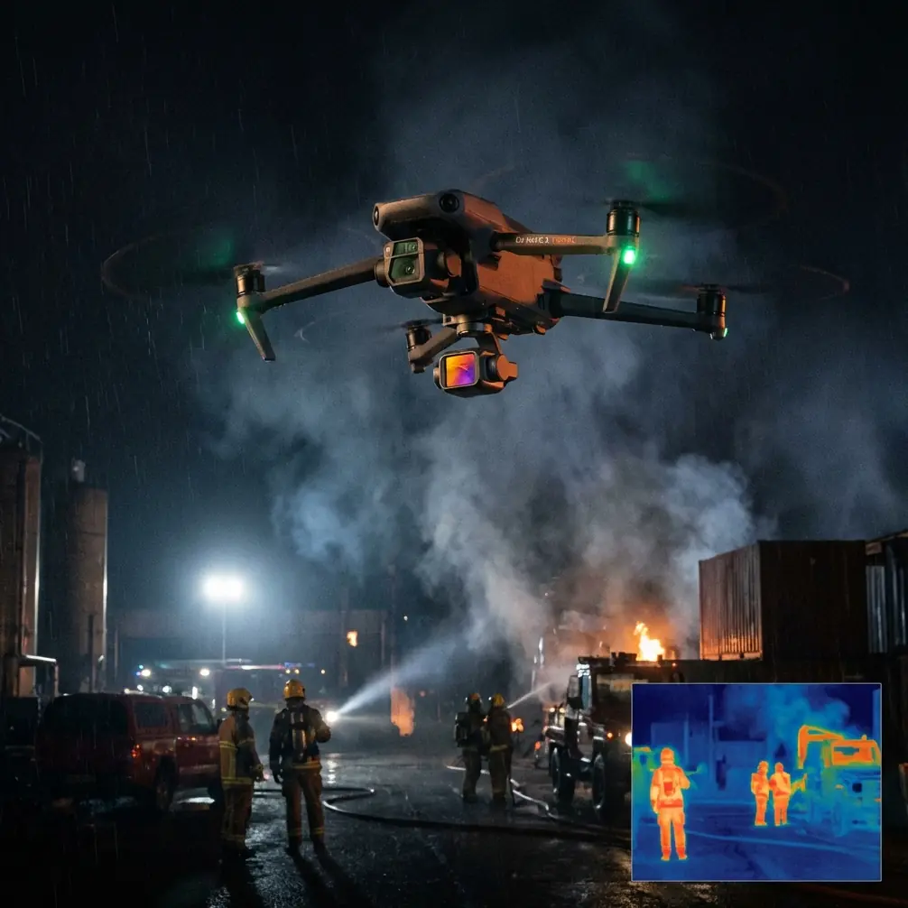
When people talk about filming roads at dusk, they usually jump straight to noise, stabilization, or color. That misses the real issue. Highway capture in low light is not just a camera problem. It is a timing problem, a coverage problem, and above all a mission-discipline problem.
That became clear to me while building a Neo 2 workflow for a civilian highway documentation project. I come from a photography background, so my first instinct was visual: protect highlights, preserve lane-marking contrast, keep traffic trails clean, and use D-Log where the scene demanded flexibility in post. Useful, yes. But what actually made the mission work was borrowing logic from a much larger world: professional aerial mapping.
The source material behind this article is not about tiny consumer drones at all. It comes from a UAV surveying solution set that details camera payload classes, aircraft pairings, and actual project accuracy outcomes. At first glance, it looks far removed from Neo 2. It isn’t. The operational thinking transfers surprisingly well, especially when the assignment is structured capture of long linear infrastructure such as highways.
Why mapping references matter when flying a Neo 2
One slide in the reference set compares interchangeable-lens payloads such as the QX1, 5100, and A7R. The numbers are revealing. Resolution ranges from 5456 × 3632 to 7360 × 4912, with payload weights around 270 g, 340 g, and 520 g respectively. Lens options include 16 mm, 20 mm, 30 mm, and 35 mm primes, and the intended applications include DOM, video capture, and oblique photogrammetry.
That matters because it shows how professionals think: not “what drone do I own?” but “what visual task am I solving, and what payload geometry, weight, and focal length support it?” Even if Neo 2 is far lighter and more compact, the same hierarchy applies. For low-light highway work, your settings and flight plan have to serve the output. Are you producing cinematic context footage? Construction progress records? Corridor visual documentation for planning meetings? Training material for roadway operations? The answer changes everything.
A second reference is even more useful. In the Suzhou Shantang Street aerial survey project, the imagery achieved better than 5 cm resolution, using 8 control points and 6 check points, with aerial triangulation check-point error also better than 5 cm, enough for a 1:500 mapping requirement. That is survey-grade language. Neo 2 is not a substitute for a dedicated mapping platform, but this benchmark is a great reminder that disciplined capture wins. Good aerial work is measured by repeatability and confidence, not just by whether a clip looks smooth on a screen.
For highway capture in low light, that means three practical shifts:
- Fly repeatable lines, not improvised arcs.
- Treat overlap and perspective consistency as operational assets.
- Manage battery timing as if the mission depends on it, because it does.
The low-light highway problem is really a contrast problem
Highways after sunset are visually deceptive. To the eye, the scene feels bright enough. To a small aerial camera, it often is not. White lane markings, reflective barriers, headlights, overhead signs, and dark asphalt create a high-contrast environment with very little forgiveness.
This is where Neo 2’s creative tools can either help or get in the way.
QuickShots and Hyperlapse are useful for context sequences, but they should not be your first move if the brief includes any sort of documentation value. Automated paths can look polished while silently sacrificing framing consistency from one battery to the next. For a cinematic opener, fine. For a repeatable corridor record, less ideal.
ActiveTrack and subject tracking can also be tempting if you want to follow a maintenance vehicle or pace traffic flow from a safe offset. But highway environments are cluttered in a way that matters to algorithms: poles, gantries, sign bridges, interchanges, and changing headlight patterns can confuse tracking behavior. Obstacle avoidance is a meaningful safety layer here, yet it should be treated as a backstop rather than a strategy. On a structured highway mission, I want deliberate pilot control first and automation second.
My preferred Neo 2 approach in low light is simple:
- Use manual exposure whenever practical.
- Reserve D-Log for scenes where you genuinely need highlight and shadow recovery.
- Keep flight lines clean and repeatable.
- Capture establishing passes before experimental moves.
- Use subject tracking only when the tracked target is predictable and the background geometry is not overloaded.
That sounds conservative. It is. And that is exactly why it works.
A field lesson from bigger aircraft: endurance changes decision quality
Another reference segment lists fixed-wing performance figures that are impossible to ignore. One platform is described with 60 to 90 minutes of endurance, while another reaches 10 hours, with cruise speeds around 70–100 km/h and 80 km/h, and a maximum of 120 km/h on one airframe. The long-range system is in a different class entirely, with a stated farthest range of 1000 km.
Neo 2 obviously lives in another category. But the principle is useful: endurance is not just about staying airborne longer. It changes how you think, how you sequence tasks, and how much risk you take late in a mission.
On a compact drone in low light, battery management becomes part of image quality. I learned this the hard way on a roadside capture where the opening pass looked perfect, but I pushed too long trying to get one more reveal shot over an interchange. By the time I started the second battery, the light had shifted, traffic density had changed, and matching the footage became harder than it should have been.
So here is the battery tip I now use every time on low-light corridor jobs:
Land earlier than your confidence says you need to, not when the battery indicator starts negotiating with you.
In practice, I divide each battery into mission roles before takeoff:
- first third for essential coverage,
- second third for alternate heights and tighter compositions,
- final third only for recovery margin and one controlled creative pass.
That last part matters. I no longer “discover” shots when the battery is low. I only execute shots that were already planned. In low light, degraded decision-making arrives before people realize it. You are balancing exposure, traffic timing, wind, signal awareness, and return routing at once. A battery reserve is not just electrical margin. It is mental margin.
Building a Neo 2 highway workflow with mapping discipline
The source slides also pair payloads with specific airframes and gimbals. For example, the lighter mirrorless payloads are matched with gimbals such as XH-YT500 and XH-YT800, and adapted to platforms like ME1500, QE640, HE840, OE1100, and FG3300. Again, Neo 2 users do not need those model names for direct purchasing decisions here. What we need is the logic behind them: payload, stabilization, and aircraft capability are treated as one system.
That same systems thinking improves Neo 2 performance in highway work.
1. Treat angle selection as a deliverable, not a style choice
If the client or internal team needs lane layout clarity, drainage context, merge geometry, or barrier placement visibility, fly for that. A low oblique pass may be more useful than a dramatic top-down reveal. Photographers often chase mood first. Highway stakeholders usually need legibility first.
2. Use D-Log selectively
In twilight scenes with bright signage and dark pavement, D-Log can preserve more usable tonal information for post-production. But flat profiles are not magic. If the scene is underexposed beyond recovery, you will simply have flatter noise. I use D-Log when I know the footage will be graded carefully and the dynamic range challenge is real. Otherwise, a more direct profile can make same-day review far easier for non-creative teams.
3. Keep your corridor segments consistent
The Suzhou project’s 1:500 output benchmark came from disciplined control and verification. Even though Neo 2 is being used here for visual capture rather than formal survey deliverables, the spirit still applies. Break a long highway into manageable sections. Start each section at a consistent height and heading. Repeat those parameters on every battery. That creates footage that can be compared over time instead of admired once and forgotten.
4. Respect obstacle avoidance, but pre-visualize anyway
Highways are full of vertical surprises: lighting masts, sign structures, cables near service roads, elevated ramps. Obstacle avoidance is useful insurance. It is not a substitute for route planning. I walk the sequence mentally before launch and identify the “decision points” where I will either continue, climb, or abort the pass.
When subject tracking helps and when it does not
ActiveTrack and related subject-tracking tools can be valuable for support vehicles, inspection convoys, or maintenance training documentation on closed or controlled civilian operations. If the vehicle path is clean and the environment is predictable, tracking lets the operator maintain composition while focusing on safety and spacing.
Open highway traffic at dusk is another story.
Headlights merge. Vehicles overlap. Reflective road furniture flickers in and out of the frame. The drone may see patterns that are not your intended subject. In those conditions, I prefer to use tracking as a rehearsed feature rather than an exploratory one. Test it on a short segment. Review. Then decide whether it earns a place in the live mission.
That distinction matters because low-light failure modes are subtle. The shot may still look smooth, but the subject relationship can drift just enough to reduce practical value.
A more useful definition of “good footage”
The reference deck includes another project from Hunan Xiangtan with about 2.3 square kilometers of aerial survey area, 10 cm image resolution, and check-point error better than 10 cm, enough for 1:1000 mapping. Those figures are not there to suggest Neo 2 can replace specialized survey aircraft. They show what “fit for purpose” looks like in professional aerial work.
That phrase should guide every Neo 2 highway mission.
Good footage is not merely stable footage. Good footage answers the operational question it was captured for. Can the planning team read the interchange geometry? Can the construction team compare stage progress from one week to the next? Can a training department show merge-lane behavior and road asset placement clearly under realistic evening conditions? If yes, the mission succeeded.
If you want to compare notes with operators who work through these kinds of corridor-capture decisions regularly, this is a practical place to start: message a UAV workflow specialist.
My go-to Neo 2 shot list for low-light highways
I keep it lean.
First, a high establishing pass to define the corridor and traffic rhythm.
Second, a medium-height oblique run focused on lane structure, barriers, exits, and signage.
Third, one controlled tracking sequence if the subject is predictable enough to justify ActiveTrack.
Fourth, a short Hyperlapse only if the light transition itself tells part of the story.
Last, one creative pass after the required material is already safe on the card.
That order is intentional. Required coverage first. Optional beauty later.
What Neo 2 does well in this role
Neo 2’s real advantage in this scenario is not brute imaging power. The larger payload references make that clear. Dedicated systems can carry full-frame or even multi-camera oblique payloads, with one five-lens setup cited at 110 million pixels total and a stated 2 cm maximum GSD for oblique photogrammetry. Neo 2 is not trying to be that.
What it offers instead is speed of deployment, lower operational friction, and the ability to collect useful low-light corridor visuals with a much lighter field footprint. For transport planners, contractors, media teams covering infrastructure, or training departments building repeatable visual records, that matters a lot.
But small drones only stay useful when pilots resist the urge to treat convenience as permission for sloppy missions. The better lesson from the survey references is discipline. Choose the visual objective. Match the flight pattern to the job. Control your battery rhythm. Use automation deliberately. Preserve consistency from one sortie to the next.
That is how a compact platform starts producing work that feels much bigger than the aircraft itself.
Ready for your own Neo 2? Contact our team for expert consultation.